Regional Exploration, Nicaragua Monte Carmelo
Highlights
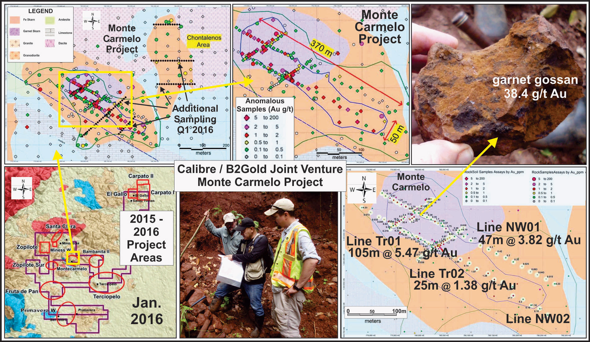
- The Monte Carmelo Gold Project is located north of the town of Rosita where geological mapping an auger rock-soil sampling has outlined skarn and structurally related gold mineralization over an area of 700 metres by 200-300 metres
- Four lines of auger holes collecting 110 rock-soil samples were completed in Q4 2015 with results including;
- North-east -orientated Line TR1 average is; 105 metres grading 5.47 g/t Au*
- North-west -orientated Line NW1 average is; 47 metres grading 3.82 g/t Au*
- Line TR2 returned; 25 metres grading 1.38 g/t Au*
- Samples in the central portion of Monte Carmelo gold project show a consistent >0.5 g/t Au gold anomaly that extends 370 m long and 35 to 100 m wide which remains open
- Additional exploration including mapping as well as surface and auger sampling is on-going and is designed to expand and further define the Monte Carmelo Targets
*Auger rock-soil samples were collected at 5 to 20 metre spacing along lines with average grades representing arithmetic averages of auger rock-soils collected along the lines
2017 100% Owned Monte Carmelo Gold Skarn Drill Results
The maiden drilling program at the 100% owned Monte Carmelo Gold Skarn Project consisting of eight diamond drill holes totalling 2100 metres has been completed and all assay results have been received. The drilling targeting high-grade gold skarn mineralization exposed on surface and tested by an extensive program of auger drilling.
All drill holes intersected skarn mineralization consisting of garnet and magnetite skarn developed in calcareous sediments, limestone, and intrusives. Mineralization consist of massive and veined zones with anomalous levels of gold and silver with variable copper associated with iron and lesser amounts of zinc, lead, and arsenic.
Drill hole MD17-006 intersected a broad iron rich zone from surface with 29.5 m grading 0.58 g/t Au, 4.9 g/t Ag and 0.22 % Cu from surface including 10.5 metres grading 1.43 g/t Au and 7.5 g/t Ag and 0.32 % Cu (0 – 10.5m).
Drill hole MD17-007 intersected a highly mineralized iron rich zone consisting of magnetite skarn averaging 0.28 g/t Au, 6.34 g/t Ag, 0.33 % Cu, and 0.20 % Zn over 14.5 metres (83.8 – 98.3 m). Additionally the hole intersected 0.36 g/t Au, 65.8 g/t Ag, and 3.51% Cu over 1.53 m (74.72 – 76.25m) and a third intercept from surface of 7.0m grading 0.45 g/t Au, 1.9 g/t Ag, and 0.11% Cu.
Diamond drill hole MD17-001 intersected 2.1 metres grading 0.36 g/t Au (36.6 – 38.7m) and a second intercept of 1.1m grading 0.16 g/t Au and 3.62 % Zn (127 – 128.1m). Drill hole MD17-002 intersected 2.0 metres grading 0.10 g/t Au and 0.48 % Cu (120.25 – 122.25m). MD17-003 intersected a narrow zone of weakly to moderately anomalous mineralization which included 331 ppm Mo (molybdenum) over 3.71 metres (110.66 – 114.37m). Drill hole MD17-004 intersected a near surface, broad mineralized zone with low grade gold and silver values grading 0.22 % Cu and 0.51 % Zn over 47.28 metres (7.62 – 54.9m). MD17-005 contains a narrow zone grading 1.19 g/t Au over 1.15 metres (50-45 – 51.6m). Drill hole MD17-008 intersected a near surface zone of 9.4 metres grading 0.15 g/t Au (0.0 – 9.4m) and a second intercept of 4.95m grading 0.14 g/t Au (63.05 – 68.0m).